We actually hit Wisconsin's high point, Timms Hill, way early in our road trip on our way eastbound. We squeezed it in between events because it was "on the way." At 1,051.5 feet, it's just a mere 1/2 mile from the car with a fantastic wooden tower you can climb to look out onto the hills of Wisconsin and smell the cheese. I'm kidding, you don't actually smell cheese.
As for Michigan and Minnesota, they were part of the latter end of our road trip when we skimmed the border of Canada. Those 2 high points rank up there with the list of "most out of the way." But, that upper peninsula of Michigan as well as northern Minnesota blew us away with beauty, again really reminding us of northern Maine.
Michigan's Mt. Arvon (1,979 feet) was the easiest of the 3, although we had to drive miles of dirt roads that could be treacherous when muddy to get there. Otherwise, we popped out of the car and walked maybe 200 yards to the signpost. There was even a picnic table for resting once we got there.
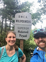
Minnesota's Eagle Mountain (2,301 feet) was more of a hike (7 miles round trip), but the trail is flat, well-marked and has very little elevation gain. In fact, the hardest part of the trail were the mosquitos and black flies. I'm pretty sure we ran most of the miles with our impeccable timing of late July, the height of bug season. But, the highpoint is in the beautiful Boundary Waters Canoe Area Wilderness with an amazing clearing overlooking the Boundary Waters when you reach the summit and with the right amount of wind, it makes for a great picnic spot.
Our last 7 high points will most likely be the most challenging for one reason or another, but hopefully next summer we'll tick off a few more!


Great pictures!
ReplyDeleteThe hill with the arrow to it is actually not eagle mountain. The trail runs west of it to go up eagle. It is often mistaken for eagle mountain as it appears prominent over whale lake.
ReplyDeletehttp://www.summitpost.org/eagle-mountain/151003
Trudged up the wrong one in winter and learned the hard way because summitpost had the same hill pictured on their site back then. Cheers to your 43!
ReplyDeleteWow Brennan! You are right ... we assumed that was Eagle Mountain because of its prominence over the lake and the way we followed the trail. Thanks for the clarification!!
ReplyDelete