Baxter State Park

J & I returned from our trip to Baxter State Park in Maine and I feel like this could spread across multiple posts with all we did!For the ADHD type, here’s the short version of the trip—
Moose sightings=1
Miles hiked=20+
Nights camped=3
Days without shower=4
Number of outhouse visits=14
Mysterious bites on body=17
Hail in the face while on top of Katahdin=too much
Wind speed on top of Katahdin=your kite would definitely fly away
NB thru-hikers spotted (that means people hiking northbound from Georgia to Maine on the Appalachian Trail)=4
Canadian plates=10
High temperature=70 degrees
Low temperature=30 degrees

And now, the long version for my journaling purposes. But you can certainly read on if you have the stamina ...

We started Friday with the 6-hour drive up to Maine. Nothing eventful there, aside from the beauty of a road trip through Maine while listening to good tunes.

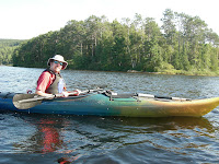
As we were picnicking in Baxter and deciding where we wanted to kayak for the afternoon, we met an older gentleman who made a suggestion because of its view of the great Katahdin—Lower Togue Pond. He even invited us to stop by his camp for some swimming if we wanted.
Doesn't this look fake?
We had a hard time finding his camp because there truly didn’t seem to be any sign of life/civilization. But we finally stumbled upon an island with multiple primitive “camps” (probably better known to most as shacks because of their lack of running water and electricity). And low and behold, the gentleman was there to greet us. Turns out, the island has been in his family for almost 100 years. It’s the only private land in the whole state park and the state couldn’t pay him enough to give it up! I don’t blame him! I’m waiting for my family to inform me we own a random island in the middle of nowhere … On our way back to the car, J spotted a moose. It only took me 10 minutes to see it myself. “Right by the tree babe. Right there.” Cause there aren’t a million trees in front of us. But once I got her in view, she was grand. We kayaked within 75 feet of it, keeping a safe distance. J was sure to go over the safety precautions in case it did charge at us, which made me move a few feet back. My first moose spotting in the Northeast and it was definitely unforgettable.


She's taking a wiz in the profile picture!


We finally settled into our first camping spot (which we reserved 4 months in advance!) and went to bed the regular camping time … around 9ish. We needed the rest though because the following day, we got up at 4am to make it to the trailhead. You see, Baxter State Park is very popular because it’s the gateway to the highest peak in Maine—Mt. Katahdin, or Baxter Peak. Rising 1 mile above ground, it’s also the northern terminus to the AT, or the beginning for some (hopefully for us in 2011). There are a few trails that take you to the top, and we chose to try the famous AT. The park restricts usage of all the trails, so you basically have to be at the trailhead by 6am to secure your spot. The park also looks out for your safety and rates the day according to the weather forecast.
Class I – Free to go
Class II – Weather is iffy, go above treeline at your own risk
Class III – Weather is iffy, some trails are closed. You may get struck by lightening.
Class IV – No one is going anywhere. Sorry if you drove 6 hours to get here, but you are SOL.

Saturday was a Class II day. It was drizzling when we started hiking at 6:30am, but we figured we’d try and see what it was like above treeline. Plus, J and I were extremely “geared” up, meaning we were decked out in all our rain gear, from head to toe. We just shake our head in disbelief when we see people hiking without rain gear. Because, in my opinion, hiking in wet clothing and shoes is just about as fun as getting my wisdom tooth pulled again, but without anesthesia. Sometimes it's inevitable, but to willingly get wet ...


Anyways, we layered up and down as we were hiking over and over again throughout the 5.2-mile hike up. Once we hit treeline, the weather hadn’t changed much beyond cold and wet with limited visibility, so we figured we’d press on. The hiking itself was pretty intense. Our thighs grew about 10 inches around from the workout and we are still wincing in pain when using stairs. The rain turned to hail once we reached the last 2 miles, but we just had to bag the peak at that point. At the summit, we pretty much turned right around after getting the celebratory picture because it was so damn cold.


Now this is where it gets dicey. The way down is supposed to be easier. But that was before Hurricane Nipple Ripper swept in. Mind you we are hiking along a ridgeline exposed to the elements. I was just about crawling to keep from blowing away. I’m not kidding. 50-mph winds with gusts up to 70 mph. Not to mention my nose was running continuously. I lost so much snot on that mountain. I wish I could have pulled out my camera to videotape it. The wind that is. When we got down, we found out we were only 2 of 8 people that summited that day. If that was a Class II day, I'd hate to see what a Class III is like!

The rest of the trip was less dangerous. We got some scoop on AT thru-hiking and climbing in the park from the rangers. We did some more hiking, but we didn’t try to summit again. Our legs really wouldn’t let us. We spent our last night at a place called Chimney Pond, a backcountry lean-to at 3500 feet. Definitely wished we could spend more time there actually. Next time. Because there will be a next time.

Chimney Pond and the mountain range in the background
Need to rest our legs
J protecting our food from da bears

PS – Where did summer go? We left our windows opened overnight and woke up to a 40-degree house.

Labels: , ,